Pay Once and Have Free Attractions Entry for 2, 3, 5 or 7 days
Welcome to Istanbul, a city that embodies the fusion of ancient history and modern urban life. As a traveler, navigating through the labyrinthine streets can be both exciting and challenging. But fear not, our comprehensive Istanbul 2024 Transport Map guide will help you make the most of your journey by providing insights into Istanbul’s public transportation network. From metro and bus lines to ferry maps, we’ve got you covered. So, let’s dive in and explore the city with ease!
Istanbul Public Transport Map 2024
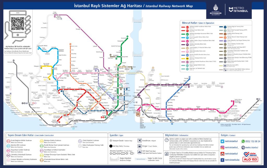
Istanbul Metro Map 2024
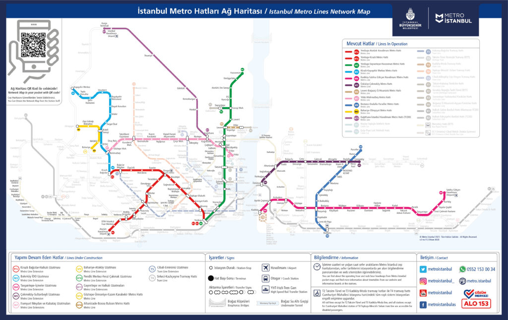
The Istanbul Metro is the backbone of the city’s transportation system. With numerous lines and stations, it connects different districts and attractions, making it an efficient and convenient way to get around. The Istanbul Metro Map 2024 provides the most up-to-date information on the network’s layout, making it easier than ever to navigate the city.
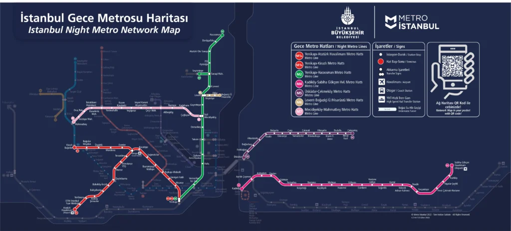
Istanbul Night Metro Map 2024
Read more about Metro in Istanbul >>
Istanbul Tram Map 2024: Glide Through the City
Trams are an integral part of Istanbul’s transportation system, offering a more traditional and scenic way to explore the city. The Istanbul Tram Map 2024 showcases the current routes and stops, ensuring that you don’t miss a single sight.
Istanbul Tram Schematic Map 2024
Istanbul Tram Google Map 2024
Read more about trams in Istanbul >>
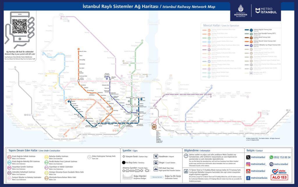
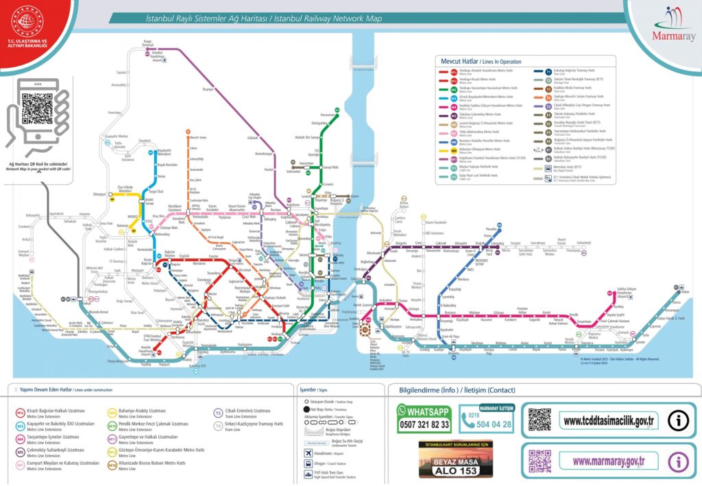
Istanbul Marmaray Map 2024
The Marmaray is a unique transportation system that connects Europe and Asia via a tunnel beneath the Bosphorus Strait. The Istanbul Marmaray Map 2024 provides a detailed layout of the route, ensuring a smooth and memorable journey.
Istanbul Marmaray Schematic Map 2024
Istanbul Marmaray Google Map 2024
Read more about Marmaray in Istanbul >>
Don’t Miss The Best Tours and Cruises in Istanbul
Istanbul Metrobus Map 2024: Speeding Through the City
The Metrobus is a rapid transit bus system that offers a fast and efficient way to traverse Istanbul’s busy streets. With dedicated lanes, the Metrobus can bypass traffic jams, making it a popular choice for commuters. The Istanbul Metrobus Map 2024 highlights the extensive network of routes and stops, so you can plan your journey with ease.
Read more about Metrobus in Istanbul >>
Istanbul Metrobus Schematic Map 2024
Istanbul Metrobus Google Map 2024
Metrobus Lines: The Expressway
Istanbul’s Metrobus network consists of a single line with numerous stations, including:
- Söğütlüçeşme
- Zincirlikuyu
- Mecidiyeköy
- Cevizlibağ
- Beylikdüzü
For more details, download the Istanbul Metrobus Routes Map 2024 PDF or visit the interactive map on the Istanbul Metro website.
Istanbul Ferry Map 2024: Sailing the Bosphorus
Ferries are an iconic and enjoyable way to explore Istanbul, offering unparalleled views of the city’s skyline and the Bosphorus Strait. The Istanbul Ferry Map 2024 showcases the various routes and docks operated by Şehir Hatları and İDO, making it easy to plan your nautical adventure.
Read more about ferries in Istanbul >>
Ferry Routes: Cruising the Waters
Some of the most popular ferry routes in Istanbul include:
- Eminönü – Kadıköy
- Eminönü – Üsküdar
- Karaköy – Haydarpaşa
- Beşiktaş – Kadıköy
- Kabataş – Princes’ Islands
To view the complete list of routes and schedules, download the Istanbul Ferry Map 2024 PDF or check the interactive IDO Ferry Docks Map.
Istanbul Ferry Map 2024 PDF
IDO Ferry Docks Google Map
Ferries from Istanbul to Adalar Map
Read how to get from Istanbul to Princes’ Islands >>
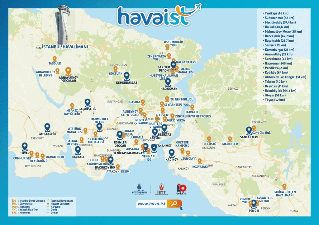
Istanbul Airport Transport Map: Gateway to the City
Istanbul’s new international airport is well-connected to the city center via various transportation options. The Istanbul Airport Transport Map (Metro) and Istanbul Airport Transport Map (Havabus) provide comprehensive information on the available routes and stops, ensuring a seamless arrival and departure experience.
More maps of Istanbul Airport >>
Airport Connections: Touchdown to Takeoff
The primary airport transportation options include:
For more information on airport transportation, refer to the Istanbul Airport Transport Maps or visit the respective websites.
Private Shuttle: Comfort and Convenience
For a stress-free transfer we recommend Welcome Pickups, a reputable and reliable 5-star airport taxi company for your transfer from Istanbul Airport. With high ratings on various platforms like Google, TripAdvisor, and Trustpilot, Welcome Pickups ensures a safe and enjoyable experience for travelers.
- Local English-speaking drivers
- Flat, pre-paid fee
- Flight monitoring for delays
- 24/7 Customer support + free cancellation
Istanbul Airport Transport Map (Metro)
Istanbul Airport Transport Map (Havabus)
Conclusion
Navigating Istanbul’s vast and diverse public transport system is now easier than ever with the comprehensive Istanbul Transport Map 2024 guide. By utilizing the updated maps and information provided in this article, you can confidently plan your journey and explore everything this incredible city has to offer. Whether you prefer the speed of the metro, the convenience of the Metrobus, or the charm of a ferry ride, Istanbul’s transport network is ready to take you where you need to go.
Frequently Asked Questions
Q: Where can I find the most up-to-date transport maps for Istanbul?
A: The most recent transport maps can be found on the respective websites for each transportation mode: Istanbul Metro, Marmaray, Metrobus, Şehir Hatları ferries, İDO ferries, and Havabus.
Q: Can I purchase an Istanbulkart for public transportation?
A: Yes, the Istanbulkart is a reusable smart card that can be used for all public transportation modes in Istanbul. You can purchase and top up the card at designated kiosks and vending machines at major stations.
Q: Are the transport maps available in English?
A: Yes, most transport maps are available in English, Turkish, and other languages on their respective websites.
Q: How do I know which transportation mode is best for my journey?
A: Depending on your destination and preferences, different transportation modes may be more suitable. For example, the metro is ideal for quick trips within the city, while ferries offer a scenic way to explore the Bosphorus Strait. Use the various transport maps to determine the most convenient and efficient mode for your journey.
Q: Are there any mobile apps available for navigating Istanbul’s public transport system?
A: Yes, there are several mobile apps designed to help you navigate Istanbul’s public transport, such as Trafi and Moovit. These apps provide real-time updates, route planning, and arrival times for various transportation modes.
You Might Be Interested in
- Best Food Delivery Apps in Istanbul: How to Order Food In
- Istanbul in May: Weather & Things to Do, Events in 2024
- April Weather in Istanbul: The Ultimate Guide for Travelers (2024)
- How to Make Turkish Coffee: Step-by-Step Recipe
- Explore Maltepe in Istanbul (Asian Side): Things to Do & See, Hotels, Restaurants (2024)
- Traveling in Istanbul with a Baby: Places to See and Tips for a Pleasant Vacation
- Istanbul Ruines and Constantinopol Sites: A Journey Through Byzantine History
- Galata Tower in Istanbul: Entrance Fee, Opening Hours, History & What to See (2024)
- Istanbul Archaeological Museums: Museums, Tickets, Opening Hours (2024)
- 8 Best Taksim Square Hotels in Istanbul from Luxury to Budget (2024)
Don’t Miss The Best Tours and Cruises in Istanbul